
 |
| Not sure this beats flying? |
Thursday 24th May
We go ashore again to download yet another weather forecast
– which again gives us winds out of the E. or E.S.E. somewhere between 10 –
20kts. Nothing new. We collect our
clearance papers from the Navy, have another coffee, then, return to SHAMAL. Our plan is for a mid-afternoon
departure. According to our cruising
information this should be a 36 hour run following the Dominican Republic
coastline, crossing the Mona Passage, then running down the west coast of
Puerto Rico. It is overcast and humid as we raise the anchor from Samana
Harbour in the D.R. A huge thunderstorm
is passing just to the south of us. As
we head out of the bay, and start the run following the coastline, the seas are
short and sharp, and on the nose. By the
next morning we start our tack out to sea to round the Hourglass Shoals. We can
tell already this is going to be a long slow trip. By evening we are sailing
with a reef in the main and full jib. I have been trying to fish, but there is
just too much Sargasso Weed about. It gets very frustrating having to wind my
line in every few minutes to clear it.
The clumps of it seem to be getting bigger and thicker.
 |
| A Small patch of Sargasso Weed! |
Evening – I have just come on watch. We are still under sail with the good old
auto pilot on. Then just before midnight we have yet another squall line
passing through. The winds are all over the place. Then they drop completely. Unbeknown to me we have also sailed into a
humongous patch of Sargasso Weed. The current is now pushing us backwards, and
the weed is starting to pile up on the back steps. I wake Alec who can smell
the weed. He says we will just motor out
of this, then be on our way again. He
starts both engines but the weed is so thick the Port engine stops pumping
water. We turn that off so not to do any damage, and ever so slowly edge our
way out using the STBD engine only. I
tell you it was like a scene from a horror movie. I thought we were going to be
engulfed by the stuff. When it is daylight Alec has to clean both salt water
inlet filters to the engines, which are clogged with weed. This is something he
now keeps an eye on and cleans out regularly . Also when motoring the weed gets
caught around the props which slows us down and causes the props to vibrate. To
clear it we have to put the props into reverse. In certain areas this was quite
often.
 |
| Boqueron |
By dawn we have crossed the Mona Passage and are running
down the west coast of Puerto Rico. It is midmorning when we finally dropped
anchor in Boqueron Harbour on the south western corner of Puerto Rico. Log 185nm. Here I am able to make a phone
call to Customs and Border Patrol to say we have arrived. This is a USA
territory. They take our details and tell us we will need to go back to
Mayaguez – back along the coastline we have just come along – to complete the
paperwork. It is now Saturday and
everything is closed till the Tuesday as Monday is a holiday being Memorial
Day. Thankfully it is not too far, and we can take a cab there. There is no way
we are backtracking in SHAMAL. This beating into the wind has truly lost its
glamour!!! Also they have told us we can go ashore over the weekend thank
goodness.
Puerto Rico – The history here is very much the same as the
other Islands, only their first inhabitants are thought to have arrived by raft
from Florida around the 1st. century A.D. Well if our trip to date
from west to east is any indication of the difficult of it, it must have been a
nightmare on a raft!!! The Tainos
arrived soon after. They named the Island Borinquen and were constantly
fighting off the Carib invades.
 |
| When do the restaurants open around here? |
Next thing the good old Spanish arrive here around 1508
totally decimating the indigenous peoples, all in their murderous greed for gold!!!
The slave trade here was also no different from the other Islands. The
Spanish-American War of 1898 freed Puerto Rico of the Spanish, and the Island
was declared a commonwealth of the United States. This is still a very much
debated question today – whether to keep the status quo, or officially become
America’s 51st state. In 2006 a massive budgetary crisis forced the
government to shut down for a couple of weeks after it literally ran out of
funds. The global economic crisis has led to huge numbers of unemployment. Then to top it off Puerto Rico was hit by
devastating Hurricane Irma in 2017 which will take years to recover from. So all in all poor old Puerto Rico has really
drawn the short straw. But, we found a positive attitude among the people we
met.
 |
| Boqueron |
Boquerón Harbour is nice and clean – we can see the sandy
bottom clearly. The town is literally humming with visitors. Street vendors are
out selling fresh juices, and the local specialty – oysters. The local
restaurants and bars are doing a roaring trade. It is hot and everyone is in
the water. We chat with the locals and other yachties over cool drinks.
On Tuesday we met up with Eddie the taxi driver who takes us
over to Mayaguez so we can complete our arrival formalities. We learnt here how
important it is to have ones paper work in order before arriving. A poor
European family just arrived, no visas, they were fined $500 each.
 |
| Lighthouse Cabo Rojo |
 |
| Hotel Copa Marina |
After five days here we are well rested and stocked up, so
up anchor and move just 8nm out to Cabo Rojo and drop anchor in the lee of the
cape. We will round the cape in the morning and do short day hops along the
southern coast. Our next anchorage is in front of Hotel Copa Marina, just north
of Gilligan Island. Again clean waters with a sandy bottom. Then it is on to Ponca. We only go ashore and
visit the port area here. Again we meet another couple heading somewhat in the
same direction as ourselves. They are on a Trawler Yacht.
 |
| Ponce |
 |
| Pelican of Ponce |
From Ponce Yacht Club we continue along the south coast to
the end of the Island. Come evening Alec was looking for an anchorage, but
winds have dropped a little, so we keep going. We do a night motor sail through
passage between Puerto Rico and the Spanish Virgin Island of Vieques. We arrive
into Ensenada Honda on the Spanish Virgin Island of Culebra just on daybreak.
 |
| Culebra |
Isa De Culebra – this is a delightful place, but we are
seeing the damage hurricane Irma did as she passed over this area last
September. Culebra means snake in Spanish, the name describing the shape of the
Island. It is only 7 miles long by 3 miles wide. We were anchored off the town
of Dewey. We spend four days here
exploring the local area, partly on foot, but also by tender. There is a small
creek cutting through the town with an old lift bridge which no longer
operates, but takes us through to the western side of the Island facing Puerto
Rico. Again beautiful clean clear waters. I am able to catch a jack to use as a
bait fish later. The township is quaint. The supermarket is housed in the
oldest building in town, with its wooden floors which lead you uphill among the
shelves.
 |
| Dinghy Dock Restaurant, Culebra |
 |
| Culebra |
We are surprised at how many people we are meeting who are
still on the move since we are nearly in hurricane season. That officially runs
from June to November.
On leaving Culebra we head for the first of the US Virgin
Islands – St. Thomas. We anchor in Long Bay off the town of Charlotte Amalie.
As we are still in American Territories we can phone in our positions which is
great. We take ourselves on a walking
tour of the town. There are many old stone buildings and wooden houses down
alleyways, now turned into cafés, restaurants and tourist shops.
 |
| Charlotte Amalie |
 |
| Charlotte Amalie |
We spend just under a
week visiting different anchorages in the US Virgin Islands. In Christmas Bay,
Great St. James Island, the pizza boat is still open for business as there are
plenty of cruisers about, many of them charter boats, which surprises us as we
are now at the beginning of hurricane season.
 |
| Charlotte Amalie |
 |
| Pizza Boat |
We move to the north side of St. John for a night, before
crossing to check into the British Virgin Islands on Jost Van Dyke Island. Here we visit the famous “Foxy’s” Beach Bar
and Restaurant. Again damage from Irma is everywhere around Great Harbour where
we anchored.
Road Town, Tortola. Before
dropping anchor we do a tour of the harbour. The inner harbour is a very sad sight
indeed. Here is home to the Sunsail and Moorings Charter Fleets. The damage
hurricane Irma did here is unbelievable. Damaged boats everywhere. Some rafted
together only just floating, others sunk at their moorings. The thing that
really stands out is most lost their masts.
It is the main charter boat base for the Islands, and is heart-breaking
to see so many damaged boats. We learn that 80-90 percent of all boats in the
US and British Virgin Islands were damaged during Irma, over 2,000 boats, and
of that somewhere between 40-60 percent were write-offs. Also, there are still many homes and
commercial buildings damaged, some will never be rebuilt. Many have new roofs,
but again blue tarpaulins dot the hillsides of homes yet to be repaired.
 |
| Foxy's, Jost Van Dyke |
 |
| Buck Island |
Our next anchorage is off Buck Island. The clean up here has
not started and it is a little concerning having one catamaran sitting high and
dry on the beach in front of us, and behind us two large ones upside down on
the beach, along with mono yachts broken and washed up on their sides or just
smashed to pieces beside them. We are
told that the tornadoes within the hurricane are what caused much of the
damage. Those along with the 9-10 foot tidal surge. Irma produced winds up to
185mph. The local Islanders who were in her path tell you she was greater than
a Category 5 – the highest category measurement to date which has maximum
sustained winds of 156mph. They feel it should be classed as a Category 6 – 7
with the high winds they had.
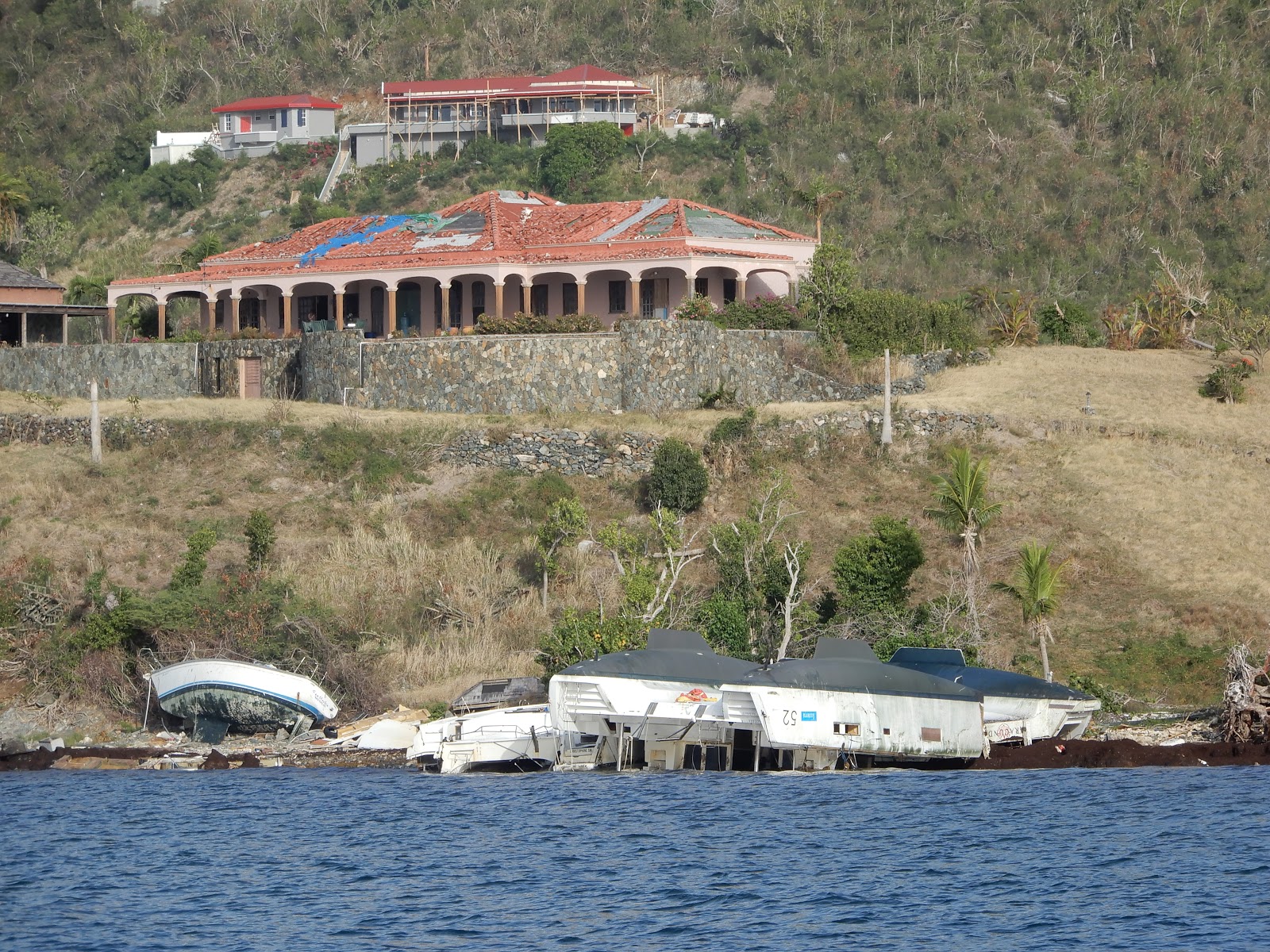 |
| Hurricane damage, Buck Island |
 |
| Jost Van Dyke |
While sitting at anchor here we see a freighter pass by with
about 15-20 brand new boats for the charter fleet. Alec believes that the
general cruisers are now subsidising the charter fleets over insurance
premiums, as they are covered if they take “reasonable precautions “ in the
event of a hurricane, where as we are not covered if we are damaged within the
hurricane areas!!!!
 |
| Sunsail boats in Road Town |
From here we sail across to Manchioneel Bay on Cooper
Island. Again the waters here are crystal clear. Also it is one of the few
places that is not showing hurricane damage. It is only a tiny place and the
buildings here are newer and have been built to a higher standard. They have
renewed any damage to docks and gardens. It was a breath of fresh air to visit
here, and what we imagine the islands looked like before Irma went through.
 |
| Cooper Island |
We find a couple more anchorage before moving to the Island
of Virgin Gorda. We stop in Spanish Town to visit Customs and Immigration to
find out the procedure for checking out. We would like to leave from the top of
the Island but discover their office there is now closed. Never mind, we sail
up to Gorda Sound for a couple of days, return to check out, then head back up
there for our last night in the Virgin Islands, before leaving for St Maarten.
 |
| Hurricane damage, Virgin Gorda |
Gorda Sound is a large bay protected all around by islands
and reefs. It is a lovely place to visit and up until Irma’s destruction, had
marinas, restaurants and holiday accommodation around the bays. The only one up
and running to any degree is in Leverick Bay. Bitter End is still not open, and
Saba Rock Island Resort is roofless.
Necker Island just to the north of the Sound, which is the
holiday resort owned by Richard Branson, was having major reconstruction work
going on.
While in the BVI’s I have caught a lovely big mutton
snapper.
Thursday 21st June and it is time to up anchor
and continue eastbound. It is an 80nm run to St Maarten. I somehow think we
will be doing a few more miles than that. Tacking out to avoid going head on
into the eastly winds.
 |
| Necker Island |
 |
| Hurricane damage |
We will sign out for this posting and continue later.
Love from
The Admiral and The Commander.
This comment has been removed by the author.
ReplyDelete